We spent the night in Dawson City and
in the morning we got up and did a little more exploring. The guys
went down to the ferry dock while we girls were putzing around. We
had been told to be up early at the ferry crossings because there
would be a line up. As it was, there was no one in line and not too
many at any one time during the day. I do suppose it has to do with
the timing of our trip. Everywhere we go, we are told we are about
two weeks ahead of the caravans. I'm not sorry to miss that mess. The
George Black Ferry across the Yukon at Dawson City is the only way to
cross without going back to Whitehorse. That is about a 1200+km trip!
No thanks.
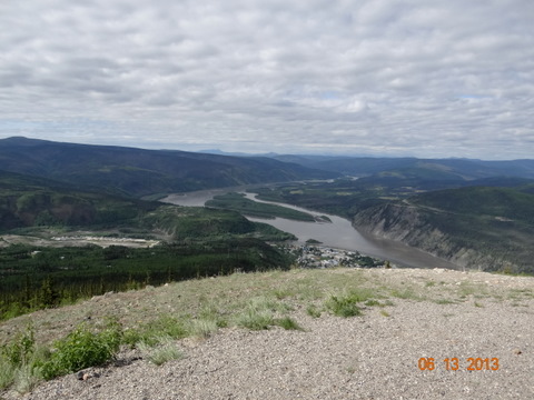
We did a little shopping for
essentials, then we all got in MinnieMee and took the road out of
town  and up to the “Midnight Dome.” This is a road that winds up
on top of the mountain above the town. I think it's the same range
that has the “Moosehide Slide” I mentioned in yesterday's post.
One can see for miles and miles from that vantage point. It was
nothing but spectacular views all around. You can see the Yukon River
and a lot of the mining as the road leads into town. You can easily
see all the “trailings” which are created by the process of
dredging the waterways looking for gold. It's quite interesting to
see. It certainly lays waste to a lot of ground. Now the town of
Dawson City is building subdivisions on top of the trailings which
just appear to be large hills of rocks.
and up to the “Midnight Dome.” This is a road that winds up
on top of the mountain above the town. I think it's the same range
that has the “Moosehide Slide” I mentioned in yesterday's post.
One can see for miles and miles from that vantage point. It was
nothing but spectacular views all around. You can see the Yukon River
and a lot of the mining as the road leads into town. You can easily
see all the “trailings” which are created by the process of
dredging the waterways looking for gold. It's quite interesting to
see. It certainly lays waste to a lot of ground. Now the town of
Dawson City is building subdivisions on top of the trailings which
just appear to be large hills of rocks.
 and up to the “Midnight Dome.” This is a road that winds up
on top of the mountain above the town. I think it's the same range
that has the “Moosehide Slide” I mentioned in yesterday's post.
One can see for miles and miles from that vantage point. It was
nothing but spectacular views all around. You can see the Yukon River
and a lot of the mining as the road leads into town. You can easily
see all the “trailings” which are created by the process of
dredging the waterways looking for gold. It's quite interesting to
see. It certainly lays waste to a lot of ground. Now the town of
Dawson City is building subdivisions on top of the trailings which
just appear to be large hills of rocks.
and up to the “Midnight Dome.” This is a road that winds up
on top of the mountain above the town. I think it's the same range
that has the “Moosehide Slide” I mentioned in yesterday's post.
One can see for miles and miles from that vantage point. It was
nothing but spectacular views all around. You can see the Yukon River
and a lot of the mining as the road leads into town. You can easily
see all the “trailings” which are created by the process of
dredging the waterways looking for gold. It's quite interesting to
see. It certainly lays waste to a lot of ground. Now the town of
Dawson City is building subdivisions on top of the trailings which
just appear to be large hills of rocks.
After returning to town from the
mountain top excursion, we drove down to the ferry to wait in line.
 We had planned another day here, but we found out Chicken, Alaska,
our next stop, is hosting “ChickenStock,” a two-day event and
campsites would be hard to come by. It's a long, arduous road from
Dawson City to Chicken, so we decided to go a day early so that we
would be gone by the time the crowds arrived.
We had planned another day here, but we found out Chicken, Alaska,
our next stop, is hosting “ChickenStock,” a two-day event and
campsites would be hard to come by. It's a long, arduous road from
Dawson City to Chicken, so we decided to go a day early so that we
would be gone by the time the crowds arrived.
 We had planned another day here, but we found out Chicken, Alaska,
our next stop, is hosting “ChickenStock,” a two-day event and
campsites would be hard to come by. It's a long, arduous road from
Dawson City to Chicken, so we decided to go a day early so that we
would be gone by the time the crowds arrived.
We had planned another day here, but we found out Chicken, Alaska,
our next stop, is hosting “ChickenStock,” a two-day event and
campsites would be hard to come by. It's a long, arduous road from
Dawson City to Chicken, so we decided to go a day early so that we
would be gone by the time the crowds arrived. Once we crossed the ferry, we drove down
the river to the Yukon
Once we crossed the ferry, we drove down
the river to the Yukon  Provincial Park. My friend from RV.net, Sue.t,
had told us about a “sternwheeler graveyard” in this area. When
the heyday of the riverboats came to a close, there was a dilemma of
what to do with them. So they placed them in “drydock” along the
river's edge. There they still sit, exposed to the elements and
rotted down. Sue had posted pictures on her blog a few years ago and
I had read it. My interest was piqued and I
Provincial Park. My friend from RV.net, Sue.t,
had told us about a “sternwheeler graveyard” in this area. When
the heyday of the riverboats came to a close, there was a dilemma of
what to do with them. So they placed them in “drydock” along the
river's edge. There they still sit, exposed to the elements and
rotted down. Sue had posted pictures on her blog a few years ago and
I had read it. My interest was piqued and I  wanted to see it. The
problem is that normally the river is down far enough that one can
walk along the riverfront at the water line and view the boats a short
walk later. Since the river is still higher than
wanted to see it. The
problem is that normally the river is down far enough that one can
walk along the riverfront at the water line and view the boats a short
walk later. Since the river is still higher than  normal, the
waterfront walk was pretty much out. I wanted to see it badly enough
I was willing to hike the trail. So Tab said he would go with me. My
only regret is that we didn't take my bear spray. I wasn't even
worried till Tab mentioned “bears.” Fortunately
normal, the
waterfront walk was pretty much out. I wanted to see it badly enough
I was willing to hike the trail. So Tab said he would go with me. My
only regret is that we didn't take my bear spray. I wasn't even
worried till Tab mentioned “bears.” Fortunately  we didn't see any
or even hear them. We hiked through some pretty dense woods and it
was muddy and wet part of the way. We had put on our “wet shoes”
which was smart. Just about the time I was ready to give up and go
back I saw something. I was pretty excited. Tab and I tromped through
the wreckage. He actually climbed up on top of a couple, but I stayed
down below and explored. We found a paddlewheel that was largely
intact with the boards missing. But the framework was there allowing
you a good look at it. We know that we were looking at four different
boats. Further on through the forest was another group of them, but
we were not aware of that until we got back and looked at the
leaflet. We probably would not have ventured deeper into the woods
without some sort of bear spray. It was a pretty cool experience and
I am glad we made it a point to go.
we didn't see any
or even hear them. We hiked through some pretty dense woods and it
was muddy and wet part of the way. We had put on our “wet shoes”
which was smart. Just about the time I was ready to give up and go
back I saw something. I was pretty excited. Tab and I tromped through
the wreckage. He actually climbed up on top of a couple, but I stayed
down below and explored. We found a paddlewheel that was largely
intact with the boards missing. But the framework was there allowing
you a good look at it. We know that we were looking at four different
boats. Further on through the forest was another group of them, but
we were not aware of that until we got back and looked at the
leaflet. We probably would not have ventured deeper into the woods
without some sort of bear spray. It was a pretty cool experience and
I am glad we made it a point to go.
Once back in the car we started up the
“Top of the World Highway.” Basically I would say that this  road
is bad and gets worse. Hah. Once again, it was a great trip. One
hundred miles. . . some is paved. The Canadian side is much, much
better than the American/Alaska side. Part is paved, part is
road
is bad and gets worse. Hah. Once again, it was a great trip. One
hundred miles. . . some is paved. The Canadian side is much, much
better than the American/Alaska side. Part is paved, part is  gravel,
part has been washed out, part has been repaired, part is soft sand,
etc. . . you get the picture. My friend Sue has always said it is 100
miles and FOUR hours. Do the math. . . that's 25 miles per hour. If
you make it quicker. . . shame on you. It took us every bit of four
hours. One section was extremely bad. There was a lot of work going
on in the area, lots of big road equipment. There was just one lane
through and Tab was leading. I couldn't see that far ahead, but when
he pulled over to the side, so did I. Turns out two 18-wheelers were
coming down the mountain and there was just one lane. We allowed all
that traffic to pass, then pulled out to take the one lane up the
hill. It was soft sand in a couple places. You couldn't get a running
start and the one side dropped off down the side, so you had to go
through it. Once my front tires plowed through it, I sped up a bit to
get my rear tires through it. You do a little slip sliding, but we
made it fine. I would not have wanted to try to take Phaeton Place
through it, that's for sure. MinnieMee is doing just great. She is
going everywhere we need her to go and getting there in good shape. We
are really happy with her.
gravel,
part has been washed out, part has been repaired, part is soft sand,
etc. . . you get the picture. My friend Sue has always said it is 100
miles and FOUR hours. Do the math. . . that's 25 miles per hour. If
you make it quicker. . . shame on you. It took us every bit of four
hours. One section was extremely bad. There was a lot of work going
on in the area, lots of big road equipment. There was just one lane
through and Tab was leading. I couldn't see that far ahead, but when
he pulled over to the side, so did I. Turns out two 18-wheelers were
coming down the mountain and there was just one lane. We allowed all
that traffic to pass, then pulled out to take the one lane up the
hill. It was soft sand in a couple places. You couldn't get a running
start and the one side dropped off down the side, so you had to go
through it. Once my front tires plowed through it, I sped up a bit to
get my rear tires through it. You do a little slip sliding, but we
made it fine. I would not have wanted to try to take Phaeton Place
through it, that's for sure. MinnieMee is doing just great. She is
going everywhere we need her to go and getting there in good shape. We
are really happy with her.
 road
is bad and gets worse. Hah. Once again, it was a great trip. One
hundred miles. . . some is paved. The Canadian side is much, much
better than the American/Alaska side. Part is paved, part is
road
is bad and gets worse. Hah. Once again, it was a great trip. One
hundred miles. . . some is paved. The Canadian side is much, much
better than the American/Alaska side. Part is paved, part is  gravel,
part has been washed out, part has been repaired, part is soft sand,
etc. . . you get the picture. My friend Sue has always said it is 100
miles and FOUR hours. Do the math. . . that's 25 miles per hour. If
you make it quicker. . . shame on you. It took us every bit of four
hours. One section was extremely bad. There was a lot of work going
on in the area, lots of big road equipment. There was just one lane
through and Tab was leading. I couldn't see that far ahead, but when
he pulled over to the side, so did I. Turns out two 18-wheelers were
coming down the mountain and there was just one lane. We allowed all
that traffic to pass, then pulled out to take the one lane up the
hill. It was soft sand in a couple places. You couldn't get a running
start and the one side dropped off down the side, so you had to go
through it. Once my front tires plowed through it, I sped up a bit to
get my rear tires through it. You do a little slip sliding, but we
made it fine. I would not have wanted to try to take Phaeton Place
through it, that's for sure. MinnieMee is doing just great. She is
going everywhere we need her to go and getting there in good shape. We
are really happy with her.
gravel,
part has been washed out, part has been repaired, part is soft sand,
etc. . . you get the picture. My friend Sue has always said it is 100
miles and FOUR hours. Do the math. . . that's 25 miles per hour. If
you make it quicker. . . shame on you. It took us every bit of four
hours. One section was extremely bad. There was a lot of work going
on in the area, lots of big road equipment. There was just one lane
through and Tab was leading. I couldn't see that far ahead, but when
he pulled over to the side, so did I. Turns out two 18-wheelers were
coming down the mountain and there was just one lane. We allowed all
that traffic to pass, then pulled out to take the one lane up the
hill. It was soft sand in a couple places. You couldn't get a running
start and the one side dropped off down the side, so you had to go
through it. Once my front tires plowed through it, I sped up a bit to
get my rear tires through it. You do a little slip sliding, but we
made it fine. I would not have wanted to try to take Phaeton Place
through it, that's for sure. MinnieMee is doing just great. She is
going everywhere we need her to go and getting there in good shape. We
are really happy with her. Top of the World Highway must have
gotten its name from the fact that you run up on top of the mountains
with incredible views all around. It truly does make you feel like
you are on the top of the world. While I don't intend to take the
road again, I am glad we did
Top of the World Highway must have
gotten its name from the fact that you run up on top of the mountains
with incredible views all around. It truly does make you feel like
you are on the top of the world. While I don't intend to take the
road again, I am glad we did it this time. The scenery was
breathtaking. Traffic? Hardly any. Again, we had heard horror stories
of people squeezing through on the road. There are very few guard
rails and sometimes the drop offs are scary. Other times it's like
driving through a meadow. There was still snow up high and we could
see how high it had been. I think when we started this trip on May
20, this road was still closed and they were working to get it open.
It is closed all winter and only opens for spring/summer/fall
traffic. There is some evidence of activity on the road and work
camps. Some is mining, other is road construction.
it this time. The scenery was
breathtaking. Traffic? Hardly any. Again, we had heard horror stories
of people squeezing through on the road. There are very few guard
rails and sometimes the drop offs are scary. Other times it's like
driving through a meadow. There was still snow up high and we could
see how high it had been. I think when we started this trip on May
20, this road was still closed and they were working to get it open.
It is closed all winter and only opens for spring/summer/fall
traffic. There is some evidence of activity on the road and work
camps. Some is mining, other is road construction. We finally hit the border into Alaska
late in the afternoon. What a
We finally hit the border into Alaska
late in the afternoon. What a  relief. . . or so we thought. We found
the roads on the U.S. side were in very poor condition and had to
drive even slower. But we eventually made it to Chicken, Alaska, our
destination for the night. We were able to get a power site, which we
didn't think was available, with ChickenStock starting on Friday. We
toured the other camps and settled on a deli sandwich for supper
since is was already close to 7 p.m. It's getting brighter out at
night. There is actually no night anymore. . . it is entirely light
outside all night. At 11:00 when we went to bed it was as bright as
noon. We have to wear our “blinders” at night or we wouldn't be
able to sleep at all!
relief. . . or so we thought. We found
the roads on the U.S. side were in very poor condition and had to
drive even slower. But we eventually made it to Chicken, Alaska, our
destination for the night. We were able to get a power site, which we
didn't think was available, with ChickenStock starting on Friday. We
toured the other camps and settled on a deli sandwich for supper
since is was already close to 7 p.m. It's getting brighter out at
night. There is actually no night anymore. . . it is entirely light
outside all night. At 11:00 when we went to bed it was as bright as
noon. We have to wear our “blinders” at night or we wouldn't be
able to sleep at all!
Tab has been panning for gold while we
are here. He's found a few flakes, but I don't think he's gotten rich
yet. LOL We have no internet here. In fact, everything in Chicken is
run by generators because they have no services here.
Today we drive 78 miles to Tok.
Hopefully we can get a full service camp there for a day. I'm ready
for a nap already!
Till next time. . .
Dale

No comments:
Post a Comment